Two brothers founded a company that created maps of virtually every neighbourhood in Toronto and beyond.
While at first glance you might think the Jelly Brothers would sell jams at markets across Ontario, a closer look reveals their extensive collection of hand-designed maps depicting neighbourhoods not only in Toronto, but across Canada.
For more than a decade, brothers Matt and Dan Jelly have been honing their craft and selling their prints through their online store, retail partners, and various markets—but, Matt tells blogTO, it all came about by accident.
“Dan has a background in computer science and I have a background in graphic design and illustration,” says Matt. “Before Jelly Brothers, I worked as a freelance designer and illustrator.”
In 2011, Matt founded the Neighbourhood Association for Central Hamilton and created his first map showing the neighbourhood's boundaries. He later began creating additional maps for adjacent areas.
“In 2012, I did a small art exhibition with some of the cards I had designed, but I didn’t think it would become an ongoing project,” he says.
Matt, who also did screen printing, took the leftover cards from the art show to a market along with his screen-printed goods and noticed that people were drawn to the cards in particular – and from there, things took off for the Jelly brothers.
Together with his brother Dan, who eventually took over the map-making while Matt began creating illustrations of landmarks, the duo has now compiled over 1,400 maps of various neighbourhoods, university and college campuses across Canada, in addition to a handful of illustrated posters with a focus on Toronto and Hamilton.
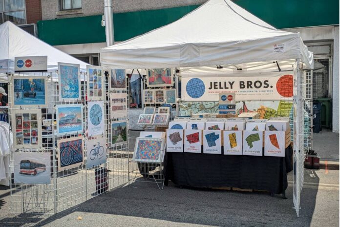
The Jelly Brothers setting up at a street festival.
“When we started, it felt more like we were running a garage sale than starting a small business – and although it still feels that way in some ways, Jelly Brothers has evolved into our full-time career,” Matt tells blogTO.
Ten years after its founding, the company is still run solely by Dan and Matt, which Matt says allows them to stay on top of what's happening and know what people want.
“It's still very hands-on and personal,” he says. “As we are the only two employees in our company, we are in constant personal contact with our customers at events – and these conversations give us insight into what we should do next.”
Such complex work requires a significant amount of time and detail, Matt says, and some maps (he points out particularly larger suburban areas and university campuses) take hours to create.
Then the always difficult task is to determine the correct boundaries and names of the individual highlighted districts.

In addition to the maps, Matt also illustrates various sights and scenes.
“Is it The Beaches or The Beach? (We offer both). Where does Roncesvalles end and Parkdale begin? (Or do they overlap?)” says Matt.
“The process often starts with talking to the people who live in those places so we can get things as right as possible, and such conversations can often lead to us updating a map or creating alternative versions.”
The special thing about maps, Matt told blogTO, is that they give people the opportunity to identify with their roots and contextualize their surroundings.
“At events in our tent, customers often find their district map in their collection and say quite specifically: ‘That’s me,’” he says.
“I think it's the same feeling we had as children when the new phone book came out and we immediately looked for our own entry. It's our little corner in a big world.”
The company's website lets you browse an interactive map that has a pin for every neighborhood it's mapped out for, probably including your own.
You can also purchase prints through Matt and Dan's website or at their two Curated Market locations in Toronto, and keep up with their market dates by following them on social media.


